Foreword
An empire
without writing.
The Inca Empire is, of all the lost states in this library, the one with the largest gap between its physical achievement and the historical record of how it was governed. The Inca administration ran an empire larger than any in pre-Columbian history with no surviving written documents and only the knotted string registers known as khipus, whose interpretation is still being worked out.
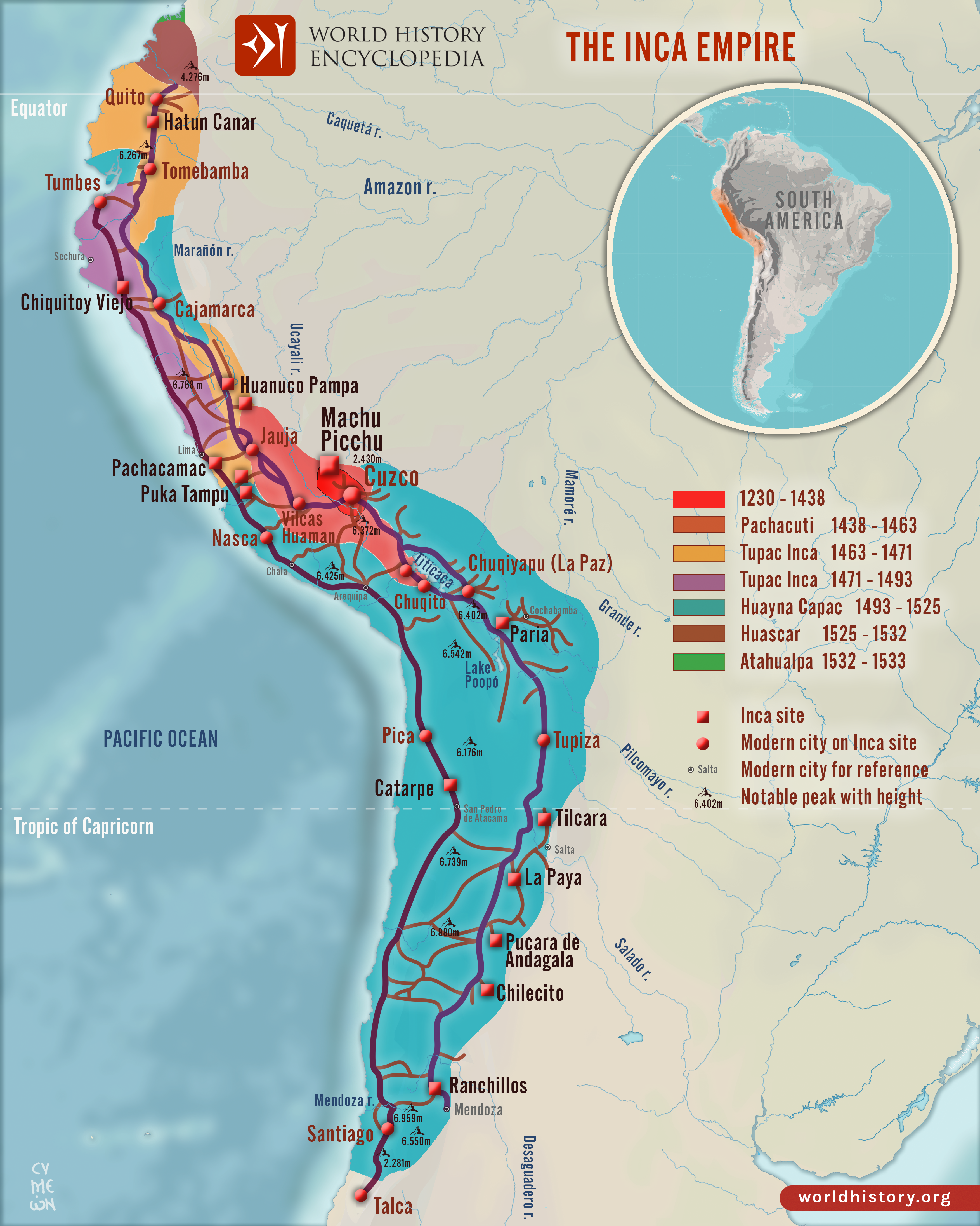
This is the obituary of Tahuantinsuyu — the Inca state, which the Inca themselves called "the four parts together" after the four administrative divisions (suyu) that radiated from the capital Cuzco. The state ran for ninety-four years (1438–1532) before the arrival of the Spaniards, and survived in a residual form at Vilcabamba in the eastern Andean cloud forest for another forty years (until 1572). Its population at peak is estimated at between six and twelve million subjects; its territory ran from southern Colombia to central Chile, including most of modern Peru, Ecuador, Bolivia, northern Chile, north-western Argentina, and parts of southern Colombia. The infrastructure it built — the eighteen thousand kilometres of the Qhapaq Ñan road network, the storehouses of the imperial supply system, the agricultural terracing that still feeds Andean villages today, the great masonry of Cuzco and the imperial sites — survives in identifiable form across all seven modern successor countries.
The volume's principal challenge is the source material. The Inca state did not have writing in the alphabetic or syllabic sense used by every other major civilisation. Its administrative records were kept in khipus, the knotted-cord registers that recorded numerical data (and, according to the most recent decipherment work by Sabine Hyland and others, perhaps a wider range of phonetic content). Almost all of the surviving khipus are post-conquest. The principal narrative sources are the Spanish chronicles of the conquest and the early colonial period — Pedro Pizarro, Pedro Cieza de León, Juan de Betanzos, Pedro Sarmiento de Gamboa, the mestizo chronicler Garcilaso de la Vega, and, most importantly, the indigenous Quechua-speaking writer Felipe Guaman Poma de Ayala (whose 1615 manuscript Nueva corónica y buen gobierno, with 398 of his own pen drawings, was lost to scholarship for three centuries and is now in the Royal Library in Copenhagen). The chronicles are not always consistent and reflect, in various combinations, the interests of their authors and their informants. This volume's account is, throughout, a best-available synthesis from these sources and from a century of archaeological work.
Despite the source difficulties, the broad outline of Inca history is well established. The chapters that follow cover that history from its Andean pre-history through the conquest and the puppet state at Vilcabamba, then the colonial and republican aftermath, then the persistence of the Quechua-speaking world today.
"Ama suwa, ama llulla, ama qhilla — do not steal, do not lie, do not be idle." — Traditional Inca moral code, preserved in Quechua