Cuzco and the central heartland
Cuzco · Peru
The imperial capital

At 3,400 metres in the Peruvian southern highlands. The Inca city was substantially rebuilt by the Spanish above the original ground level, but the polygonal masonry of the Inca walls is visible throughout the central core: Loreto, Hatunrumiyoc (with the famous twelve-angled stone), the survived sections of the Coricancha (under the Santo Domingo monastery), the surviving Aclla Huasi compound, and the central streets that follow the original Inca grid. The Cuzco cathedral on the Plaza de Armas occupies the site of the palace of Inca Viracocha. Sacsayhuamán, on the hill above the city, is the largest single piece of surviving Inca monumental construction.
Sacsayhuamán · Peru
The great fortress and ceremonial complex

On the hill immediately above Cuzco, at 3,700 metres. The three tiers of zigzag walls in massive polygonal masonry (the largest individual stones weigh over 100 tonnes) constitute the most spectacular Inca stonework anywhere. The visible structures represent only about twenty percent of the original site — the Spaniards quarried much of the remaining material for the colonial city below. Annual Inti Raymi festival on the 24th of June reconstructs the imperial winter-solstice ceremony with several thousand participants.
Pisac · Peru
The Sacred Valley

At the entrance to the Urubamba (Sacred) Valley, 33 km north-east of Cuzco. The site complex on the ridge above the modern town includes substantial residential terraces, agricultural terracing extending for several kilometres along the ridge, the so-called Intihuatana (the "sun-tying-post," a carved astronomical reference stone), and the largest pre-Columbian cemetery in the central Andes (visible from a distance as a pockmarked cliff face on the opposite side of the valley). The market in the modern town is one of the principal indigenous textile markets in southern Peru.
Ollantaytambo · Peru
The fortress and royal estate

75 km north-west of Cuzco, in the lower Sacred Valley. A Pachacuti-period royal estate; the modern town below the fortress preserves the original Inca residential grid almost intact (the houses are still inhabited; the streets still run on the Inca plan; the irrigation channels still run from the Inca period). The fortress above contains the great Temple of the Sun with its six massive monolithic walls (the stones were quarried four kilometres away on the opposite side of the valley and transported across the Urubamba river to the construction site). The site of Manco Inca's victory over the Spaniards in 1536.
Machu Picchu · Peru
The cloud-forest royal estate

At 2,430 metres in the cloud forest above the Urubamba river, 75 km north-west of Cuzco. The single most-visited Inca site, with about 4,000 visitors per day (timed-entry tickets required). The site includes the principal residential and agricultural sectors, the Temple of the Sun with its astronomical alignments, the Intihuatana stone, the Sacred Plaza with the Temple of the Three Windows, and the agricultural terraces below. Access is by train from Cuzco (3.5 hours to Aguas Calientes) plus bus or walk up to the site. Plan three to four days in the region including travel; one day for the site itself.
Choquequirao · Peru
The other Machu Picchu

A cloud-forest royal estate site of comparable size and quality to Machu Picchu, perhaps thirty kilometres further west. Accessible only by a strenuous four-day round-trip trek from the village of Cachora. The trek descends about 1,500 metres into the Apurímac canyon and climbs back out the other side. The site itself has been only partially excavated (excavation is ongoing) and receives perhaps a hundred visitors a day, against Machu Picchu's four thousand. The single best Inca site for solitude. A planned cable-car project from Cachora has been controversial; if completed it would substantially change the access situation.
The Cuzco hinterland
Tipón · Peru
The hydraulic gardens
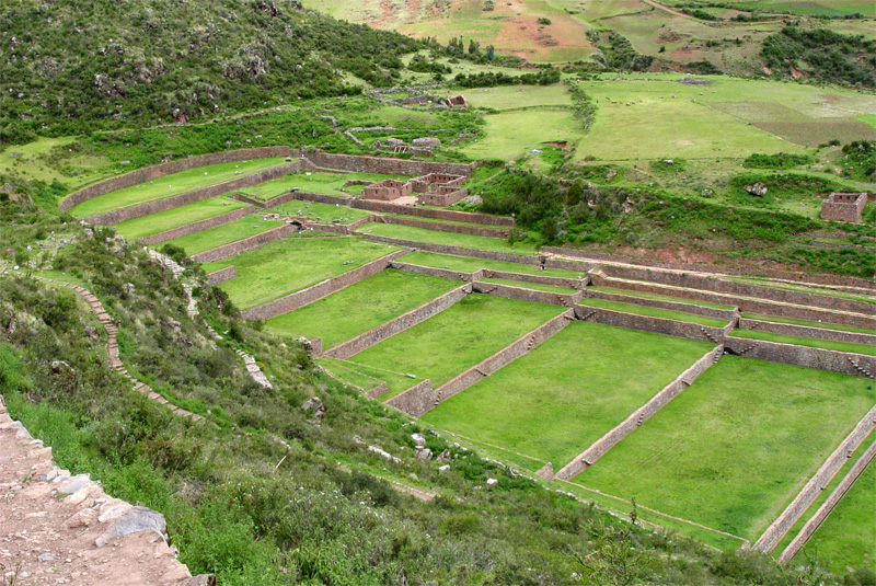
20 km east of Cuzco. The royal estate of Yahuar Huacac (the seventh Inca, Pachacuti's grandfather). The site preserves an extraordinary set of agricultural terraces fed by a network of stone-built irrigation channels, with substantial surviving fountains. The hydraulic engineering — water distributed by gravity through carefully calibrated channels to each level of the terraced gardens — is among the finest surviving Inca-era water works. Quiet site, less visited than the Sacred Valley.
Moray · Peru
The agricultural research station

In the high plateau above the Sacred Valley, near Maras. Three concentric circular depressions cut into the limestone, each ringed with terraces stepping down to the central platform. The temperature difference between the highest and lowest terraces is about fifteen degrees Celsius, simulating the climatic conditions of several different altitude zones in a single site. The interpretation as an agricultural experimental station (where Inca agronomists adapted crops from low to high altitudes through controlled cultivation at successive temperature ranges) is the standard modern reading, though the original Inca function is not fully documented.
Vilcabamba · Peru
The last capital

The cloud-forest capital of the Vilcabamba state (1537-1572), identified as the site of Espíritu Pampa by Gene Savoy's 1964 expedition. Difficult to reach — a multi-day trek from the trailhead at Huancacalle, through cloud forest and across river gorges. The site is partly excavated; substantial Inca-era residential and ceremonial architecture survives in the forest. The site is largely empty of visitors. The associated site of Vitcos (the secondary residence) is more accessible from Huancacalle and is the location of the white-rock huaca Yurak Rumi, the principal sacred object of the Vilcabamba state.
Raqchi · Peru
The Temple of Viracocha

120 km south-east of Cuzco on the road to Lake Titicaca. The principal surviving temple of Viracocha (the Inca creator deity), with the central wall standing 14 metres high — the tallest Inca structure to survive into the present. Substantial associated qollqa (storehouse) complex on the surrounding hill. A canonical stop on the Cuzco-Puno overland route.
The northern empire
Ingapirca · Ecuador
The northern imperial site

The largest surviving Inca site in Ecuador, in the Cañar province at 3,160 metres. The principal structure is the Temple of the Sun, built in the polygonal masonry style of imperial Cuzco; the site also includes substantial Cañari-period and Inca-period residential architecture. Built under Topa Inca and expanded under Huayna Capac. The Spanish destruction of the site was less complete than at most Peruvian Inca sites, partly because of its remote location.
Tomebamba · Ecuador
The Inca second capital

Modern Cuenca was built directly on top of the Inca administrative centre of Tomebamba, the principal northern imperial capital under Huayna Capac. The Inca-era foundations are visible in the Pumapungo archaeological park on the southern bank of the Tomebamba river through central Cuenca. The Pumapungo Museum on site holds an exceptional collection of pre-Hispanic Andean artefacts.
Quito · Ecuador
Atahualpa's home

The pre-conquest capital of the northern empire (under Topa Inca's son and grandson). The Inca city was substantially destroyed during the civil war and the conquest; the colonial city was built directly on top of it. The major Inca-period site within the modern city is the Yavirac/Panecillo hill, with surviving terracing. The principal Inca-era museum collections are at the Museo Casa del Alabado in the old city.
The Bolivian altiplano
Tiwanaku · Bolivia
The pre-Inca metropolis

Not Inca — the principal pre-Inca highland site, capital of the Tiwanaku state c. 600–1000 AD. But the architectural style and the religious tradition that the Inca state inherited from Tiwanaku — through the Lake Titicaca region — make this an essential stop on any Inca-related tour. The site preserves the Akapana stepped pyramid, the Kalasasaya enclosure with the Gateway of the Sun, the Puma Punku quarry-cut megalithic platform (engineering ambitions on a scale that has invited various pseudoscientific interpretations), and the surrounding ceremonial complex. 72 km west of La Paz. UNESCO World Heritage.
Isla del Sol · Bolivia
The mythological origin point

The island in southern Lake Titicaca where, by Inca cosmology, Manco Cápac and Mama Ocllo — the founder ancestors of the Inca lineage — emerged from the lake and began their walk north to found Cuzco. The site holds the Sacred Rock (the principal Inca pilgrimage destination in the Lake Titicaca region), the Chinkana labyrinth, and substantial residential terracing. Boat access from Copacabana on the lake's southern shore. UNESCO World Heritage.
Potosí · Bolivia
The colonial silver city

Not Inca but colonial — the great silver-mining city that financed the Spanish Habsburg empire and worked indigenous mita labour to death in the Cerro Rico above the town for three centuries. UNESCO World Heritage. The Casa de la Moneda (the colonial mint, now a museum) preserves the silver-coining infrastructure. Tours of the mines themselves are available; conditions inside the mines are still hazardous and the mines continue to operate.
The coast and the south
Chan Chan · Peru
The Chimú capital
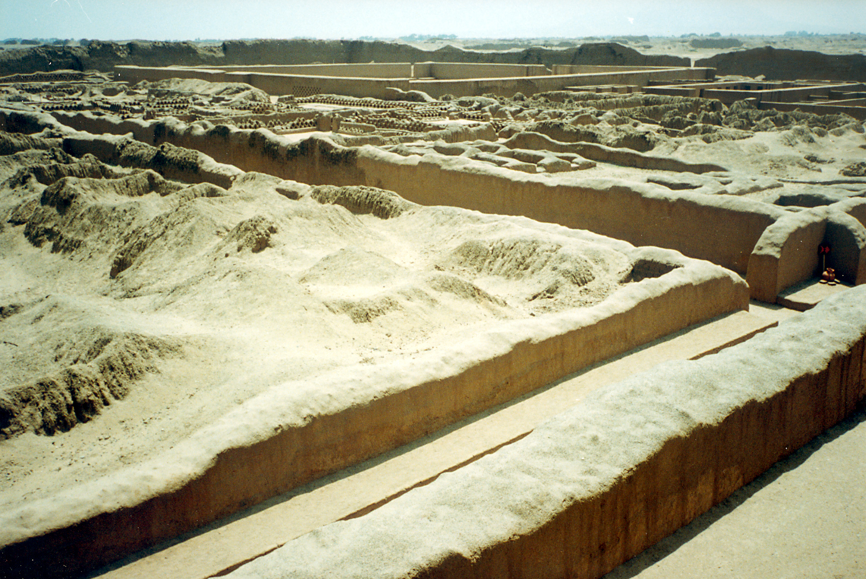
The largest pre-Columbian city in South America (pre-Inca Chimú, c. 900–1470). Outside modern Trujillo. About twenty square kilometres of mudbrick architecture, with nine major royal compounds (the so-called ciudadelas), each enclosed by walls eight to twelve metres high. Conquered by Topa Inca in c. 1470 and depopulated by the Inca administration. UNESCO World Heritage and on the World Heritage in Danger list due to erosion and water damage.
Pachacamac · Peru
The coastal pilgrimage centre

40 km south of Lima. The principal pre-Inca and Inca-period pilgrimage centre of the central Peruvian coast, with continuous religious occupation from about 200 AD to the conquest. The Inca conquerors did not destroy the existing cult of Pachacamac (the creator deity); they incorporated it into the imperial pantheon as a parallel to the Cuzco cult of Viracocha. The site includes the great Temple of the Sun built by the Inca on the seaward-facing terrace; the older Pachacamac pyramid; and substantial residential and storage architecture.
Pumamarca and Qhapaq Ñan · Argentina
The southern frontier

The Inca presence in north-western Argentina — modern Salta and Jujuy provinces — is the empire's southern administrative frontier. The road system can still be walked or driven across substantial sections, with surviving way-stations (tampus) at Inka Cueva, Punta Corral, and elsewhere. The Pumamarca site outside Salta preserves substantial Inca-period administrative architecture. The Mountain of the Seven Colours at Purmamarca is a natural feature of the Quechua-speaking Andean cultural area.
San Pedro de Atacama · Chile
The southernmost Inca outpost

The Atacama region of northern Chile was administered by the Inca state through a series of small administrative centres and the southern continuation of the Qhapaq Ñan road network. The site of Pukará de Quitor outside San Pedro is a pre-Inca and Inca-period fortress preserving the southern frontier installation. The Atacama desert environment has preserved Inca-period textiles and human remains (the famous "Atacama mummies") in extraordinary condition. The Padre Le Paige Archaeological Museum in San Pedro holds an exceptional regional collection.